


INDONESIA

*kindly click on the poster for larger version
Medan

*kindly click on the poster for larger version
Medan is the fourth largest city in Indonesia after Jakarta, Surabaya and Bandung. With a population of about 2 million people it is the largest city outside of Java. There is no single ethnic group forming a majority; the largest ethnic groups are the Chinese, Javanese, Toba-Batak, Minangkabau, Mandailing Batak, Karo Batak, Southern Indians, and Northern Indians, and there are many more ethnic minorities.
Each ethnic group contributes to thousands of tasty, mouth-watering dishes found in every corner of Medan. They offer to locals and tourists alike dozens of food streets and hawker centres to suit their appetite at any time of the day. From the sweet Javanese cuisine, to delicious Batak grilled pork, to hot Padang dishes, from savoury Chinese noodles, to spicy Indian curry, this varied cuisine is available 24-hours a day, 7-days a week. It is obvious why the locals are so into food. The city itself is quite well known for "food-tourism", especially amongst other Indonesians.
It's interesting to contrast the old, Dutch style green areas, with parks, lawns, and huge old Dutch houses (now turned into government offices or commercial business) and the hundreds and hundreds of newer, shoddy shophouses sprawled together by the hundreds in the commercial areas along with a few modern style malls.
Look out for the motor becaks! A sort of motorized rickshaw, they are a common site throughout Medan, spewing black smoke everywhere.
Overall, Medan isn't really a tourist destination, but it's a convenient stepping stone to other places like the 'weekend getaway' Brastagi, the island of Penang, Malaysia and, of course the ever popular, beautiful crater lake Lake Toba.
3D2N Medan Lake Toba Tour
North Sumatra, Indonesia

*kindly click on the poster for larger version
Lake Toba (Danau Toba) is the largest volcanic lake in the world and is in Sumatra, Indonesia. Samosir Island within the lake is the island within the island of Sumatra.
Lake Toba is an immense volcanic lake covering an area of 1707 sq km (1,000 sq km bigger than Singapore) with an island in the center. Formed by a gigantic volcanic eruption some 70,000 years ago, it is probably the largest resurgent caldera on Earth. Some studies say it might have been associated with causing previous ice age/climate change and the largest human population bottleneck ever. Genetic estimates suggests that there were only a few thousand individuals that survived the catastrophe. The island in the middle - Pulau Samosir - was joined to the caldera wall by a narrow isthmus, which was cut through to enable boats to pass; a road bridge crosses the cutting. Samosir Island is the cultural centre of Batak tribe who are mostly Christians in the modern days.
Lake Toba used to be popular tourist destination but now not many tourist come, which means many services, no crowds, cheap prices and friendly locals grateful for your business. It is a great laid back place to chill out for a few days after jungle trekking etc. The location is very popular with Chinese tourists around Chinese New Year, when availability drops dramatically and accommodation costs are known to sky rocket.
3D2N Medan Shopping Tour
North Sumatra, Indonesia

*kindly click on the poster for larger version
3D2N Medan Parapat Berastagi Tour
North Sumatra, Indonesia

*kindly click on the poster for larger version
Many tourists choose to use Medan as a quick thru-point to travel elsewhere in Sumatra, but the city offers a glimpse of a large Indonesian city still unfrequented by western tourists, and shouldn't be quickly dismissed. However, Medan is more chaotic and has a bit more litter than Jakarta or Denpasar and open sewers abound. Furthermore, not as many people speak English in Medan as in other large Indonesian cities, but even a short list of useful expressions goes a long way, and Sumaterans are still unjaded by westerners.
Medan hosts a great lot of very nice Art Déco buildings from the Dutch colonial era, like the Old City Hall, the Post office, the Great Mosque and many business buildings in and around Jl. Ahmad Yani. Some of them are in horrible shape, but most of them maintain their old splendour.
Maimoon Palace (1880-1890)
Image:Great mosque in Medan.JPG
Great Mosque (1906)
Maimoon Palace
Vihara Borobudur (Buddhist Temple)
Vihara Gunung Timur (Chinese Temple)
Mesjid Raya Mosque
Merdeka Walk (5 mins from Kesawan Square)
Tondi Gallery (Contemporary Arts Exhibitions by local artists)
Annai Velangkanni (Catholic Shrine with Tamil Hindu-style architecture)
Shri Mariamman (Tamil Hindu Temple)
5D4N Medan Lake Toba Pantai Cermin Tour
North Sumatra, Indonesia

*kindly click on the poster for larger version
Bali

*kindly click on the poster for larger version
Bali, the famed Island of the Gods, with its varied landscape of hills and mountains, rugged coastlines and sandy beaches, lush rice terraces and barren volcanic hillsides all providing a picturesque backdrop to its colourful, deeply spiritual and unique culture, stakes a serious claim to be paradise on earth.
With world-class surfing and diving, a large number of cultural, historical and archaeological attractions, and an enormous range of accommodations, this is one of the world's most popular island destinations and one which consistently wins travel awards. Bali has something to offer a very broad market of visitors from young back-packers right through to the super-rich.
3D2N Truly Bali Free & Easy Tour
Bali, Indonesia
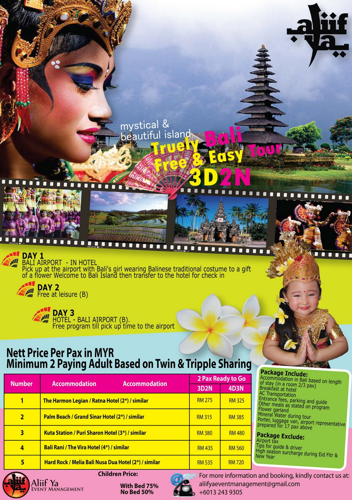
*kindly click on the poster for larger version
Kuta is the best known tourist resort area on the island of Bali in Indonesia. With a long broad Indian Ocean beach-front, Kuta was originally discovered by tourists as a surfing paradise. It has long been a popular stop on the classic backpacking route in South East Asia. Back in the 1980s they used to talk about the three Ks: Katmandu in Nepal, Khao San Road in Bangkok and Kuta. Today Kuta still attracts some hardcore backpackers as well as families and tourists from all over the world, and is most notably a playground for young visitors from Australia.
Due to the ever increasing popularity of Bali, Kuta is continually developing, and is not short of unsightly, poorly planned buildings. It can come across at times to be chaotic, overcrowded and congested. However, amongst all the mayhem this place somehow works, and hundreds of thousands of visitors enjoy their time in Kuta every year.
Infrastructure has come a long way in Kuta, although it is still insufficient for the amount of visitors who stay in the area. Some side alleys still have significant potholes and road rules still don't mean very much. Most roads are constantly busy with motor scooters, metered taxis and private cars. Instead of using signals, locals and the seasoned travellers honk their motor vehicles to signal overtaking or squeezing into a tight spot near you. Oftentimes cars fold in their side mirrors when negotiating narrow single lanes with parked vehicles. Now you can access free wifi in local convenience stores, restaurants, cafes and hotels. There are half a dozen prepaid mobile phone sim cards available everywhere with competitive top up plans. Touts will persistently try to get to buy something from them, whether you're walking on the streets or seated in a restaurant.
The five km long sandy stretch of Kuta is arguably the best beach front in Bali. The beach is safe, partially clean, well-maintained, although the beach vendors remain annoying pushing massages, hair braiding, cigarettes and surf boards. The long wide stretch of sand is often full of sunbathers and although most of the serious surfers have moved on to newer pastures, there are still plenty of surf dudes around at most times of the year, and especially so during peak season. As you move north along the beach to first Legian and then Seminyak and Petitenget it becomes progressively quieter and less frenetic.
The area of south Kuta closest to the airport is more correctly known as Tuban, but this name is rarely used. Once the sun goes down, Kuta is the rough and ready party zone of Bali, even after the tragic events of 2002. Even the most hardened of party animal will find something to please them on Jalan Legian at night.
Legian is a beachfront town in South Bali, located north of Kuta and south of Seminyak. Stretching north from Kuta, Legian offers the same easy access to shops and bars but a slightly more relaxed and less chaotic feeling. The northern area of Legian bordering Seminyak offers a bit of an escape from the crowds and is also a popular surf beach.
3D2N Bali Glorious Package
Bali, Indonesia

*kindly click on the poster for larger version
Nusa Dua is a peninsula in South Bali, well known as an enclave of high end hotels. The place name Nusa Dua can be used in two ways: either it can refer to the entire eastern side of the Bukit Peninsula at the southern tip of Bali, or it can refer to the purpose-built, safe and rather sterile tourist enclave (Kawasan Pariwisata, quite literally Tourism District) at the southeast side of this peninsula.
Nusa Dua understandably gets a lot of bad press amongst travelers as it is so artificial and sanitised. That does not change the fact though that the beaches here are glorious - white sand, deep, long and safe for swimming. The public beach at Geger is the best to head to if you are not staying at Nusa Dua. This is also home to one of the best museums in Bali. The fact that it is nearly always empty is testament that most visitors who stay here in the least Balinese part of the island is, not unsurprisingly, rather disinterested in learning much about Bali.
The Nusa Dua enclave has three manned gates and everyone entering is subject to a security search. This can have a slightly claustrophobic effect, and only contributes further to the impression that you are in an artificial location.
Splendid Bali Holiday Ground Package
Bali, Indonesia

*kindly click on the poster for larger version
Ubud, a town in central Bali, is far removed from the drunken bikini scene in Kuta, and is regarded as the cultural centre of Bali. It is famous as an arts and crafts hub, and much of the town and nearby villages seems to consist of artists' workshops and galleries. There are some remarkable architectural and other sights to be found, and a general feeling of well being to be enjoyed, all thanks to the spirit, surroundings, and climate of the place.
While Ubud seems to outsiders like one small town, it is in fact fourteen villages, each run by its own banjar (village committee). Ubud has grown rapidly, and some central parts are creaking under the strain of coping with the number of visitors. That said, most development is sympathetic to the zeitgeist, if not designed specifically in the local style. Growth continues apace, but there are still terraced rice fields along the rivers and away from the town centre, regular, quiet village life carries on relatively undisturbed. Besakih is known as the Mother Temple of Bali. Besides being the most important temple for the whole of the island, another attraction of Besakih, actually a complex of temples is its dramatic location on the southern slopes of Mount Agung.
The usual way to get to Besakih is from Klungkung. Besakih is about 20km north of the town centre. The road is not too bad, if a little winding at times. There is also a back road to Besakih south from Kintamani, and the hour-long drive is beautiful as you pass through forests, villages and fields. The road meets the main Besakih-Klungkung road just before the entrance to Besakih.
If you are coming from the eastern end of the island, such as from Amed, Tirta Gangga or Candidasa, you can also get to Besakih by taking a smaller inland road from Karangasem. The road goes through small villages such as Selat and the Bukit Putung lookout, and meets the Besakih-Klungkung road at Rendang, where you turn north (right) to head up to Besakih. The official car park fee at Besakih is Rp 5,000 per vehicle.
Bemos run to Besakih from Klungkung. They are most frequent in the morning. You may have to change bemos at Rendang halfway between Klungkung and Besakih.
Outbound Group Package
Medan - Lake Toba, Indonesia
Padang - Bukit Tinggi, Indonesia
Bandung, Indonesia
Bali, Indonesia
Yogjakarta, Indonesia
Jakarta - Bandung, Indonesia
Ho Chi Minh City, Vietnam
Tianjin - Beijing, China
Guangzhou - Shenzhen, China

*kindly click on the poster for larger version
Padang

*kindly click on the poster for larger version
Padang, the capital of the province of West Sumatra, is mostly used by tourists as an access point to Bungus Bay, the surfing sites of the Mentawai Islands the inland hills of Bukittinggi and the Kerinci Seblat National Park.
That said the city is very pleasant with a nice promanade along the beach, distinctive Padang architecture and wonderfully friendly people. The city is also the home of the delicious Padang food and the town is stuffed with restaurants and street stalls.
Museum Adityawarman
Taman Budaya (Cultural Park)
Pantai Air Manis (Sweet Water Beach)
It is most famed for Batu Malin Kundang (Stone of Malin Kundang), a stone shaped like a prostrating man. According to local legend, this stone is Malin Kundang , the ungrateful son who disowned his poor mother after coming home as a rich man from his travels. His mother cursed him into stone, as well as the remains of his ship, which can also be seen near his stone. There is a tidal island from the beach here, with nice clean (by Indonesian standards) water and sand.
Pantai Padang (Padang Beach)
You can ride the bendi (a horse-drawn carriage) along the beach, and stop by the rows of shops to eat some rujak as you watch the waves.
Sitti Nurbaya Bridge
A beautiful bridge especially at night. Sitti Nurbaya is the eponymous character in a classical literary novel.
Ramayana
World class shopping area with a variety of goods. A must see.


3D2N Persona Padang
Padang, Indonesia
*kindly click on the poster for larger version
3D2N Padang Shopping Spree
With Adibah Noor
Padang, Indonesia
*kindly click on the poster for larger version
Bukit Tinggi

*kindly click on the poster for larger version
There are some interesting legends surrounding the foundation and naming of “High Hill” Bukittinggi. The city has its origins in five villages which served as the basis for a marketplace. The city was known as Fort de Kock during colonial times in reference to the Dutch outpost established here in 1825 during the Padri War. The fort was founded by Captain Bauer at the top of Jirek hill and later named after the then Lieutenant Governor-General of the Dutch East Indies, Hendrik Merkus de Kock.
The first road connecting the region with the west coast was built between 1833 and 1841 via the Anai Gorge, easing troop movements, cutting the costs of transportation and providing an economic stimulus for the agricultural economy. In 1856 a teacher-training college (Kweekschool) was founded in the city, the first in Sumatra, as part of a policy to provide educational opportunities to the indigenous population. A rail line connecting the city with Payakumbuh and Padang was constructed between 1891 and 1894. During the Japanese occupation of Indonesia in World War II, the city was the headquarters for the Japanese 25th Army, the force which occupied Sumatra. The headquarters was moved to the city in April 1943 from Singapore, and remained until the Japanese surrender in August 1945.
During the Indonesian National Revolution, the city was the headquarters for the Emergency Government of the Republic of Indonesia (PDRI) from December 19, 1948 to July 13, 1949. During the second 'Police Action' Dutch forces invaded and occupied the city on December 22, 1948, having earlier bombed it in preparation. The city was surrendered to Republican officials in December 1949 after the Dutch government recognized Indonesian sovereignty. The city was officially renamed Bukittinggi in 1949, replacing its colonial name.
From 1950 until 1957, Bukittinggi was the capital city of a province called Central Sumatra, which encompassed West Sumatra, Riau and Jambi. In February 1958, during a revolt in Sumatra against the Indonesian government, rebels proclaimed the Revolutionary Government of the Republic of Indonesia (PRRI) in Bukittinggi. The Indonesian government had recaptured the town by May the same year.
Bukittinggi is a small town, so these places are within walking distance with each other (15-30 minute walk).
Sianok Canyon (Ngarai Sianok) and the Japanese Caves (Lubang Japang), a network of underground bunkers and tunnels built by the Japanese during World War II. There is a two-story observation tower that overlooks the Sianok Canyon. Ticket price: Rp4,000 (Aug 2009). During dusk you can observe megabats flying from the gorges to the forest in order to feed from the fruits on the trees. This is also a good place to get in contact with guides for tours such as to Lake Maninjau (see below) or jungle/hiking trips through the Canyon.
Fort de Kock
A fort built by the Dutch (nothing is left, only a water reservoir is on top of the hill) and Bundo Kanduang Park. The park includes a replica Rumah Gadang (traditional house), used as a museum of Minangkabau culture (many curiosities, such as stuffed animals with two heads and six legs, model houses and traditional dresses, foreign currencies... entrance Fee an extra Rp 1000 [Aug 2009]), and a zoo with a few very sad Orang Utans, a few expired species which are still rotting in their cages, two obese bears - not exactly a example in modern animal keeping. The Dutch hilltop outpost Fort de Kock is connected to the zoo by the Limpapeh pedestrian overpass. Ticket price: Rp8,000 (Aug 2009), camera Rp100,000 (June 2008).
House of Bung Hatta (the first Vice President of Indonesia).
Clock Tower (Jam Gadang)
There are horse carriages waiting around the Jam Gadang area. Please be cautioned that the rides are very costly, therefore please ask for their rates first.
Bandung

*kindly click on the poster for larger version
Bandung is the capital city of West Java, and the third largest city in Indonesia after Jakarta and Surabaya. Nicknamed Parijs van Java (Paris of Java) by the Dutch for its resemblance to Paris and European atmosphere back at the colonial times. Bandung also earned another nickname as Kota Kembang, literally meaning the Flower City since Bandung used to have a lot of flowers.
Located at the altitude of 768m with the surroundings of lush and beautiful Parahyangan mountains make the climate mild and pleasant. The city has been well known for the universities, apparel products and a great place for gastronomic adventure. Nowadays, Bandung has become a very popular weekend escape for Jakartans, who would crowd the city on weekends and national holidays.
Although the oldest written reference to the city dates back to 1488, there were numerous archaeological finds of Australopithecus (Java man) that lived on the banks of Cikapundung river and the shores of Bandung's Great Lake.
In the 17th-18th century, the Dutch East Indies Company (VOC) created small plantations in Bandung, with a road to Batavia (today's Jakarta) completed in 1786. In 1809, Louis Bonaparte, the ruler of the Netherlands and its colonies, ordered the Dutch Indies Governor H.W. Daendels to improve Java's defenses against the threat of the English, who occupied the nearby Malay Peninsula. Daendels responded by building the Great Post Road (De Groote Postweg) that stretched about 1000 km between the west and the east coasts of Java. Because north coast was in the form of impassable swamps and marshes at the time, the road was diverted through Bandung along what is now Jalan Asia-Afrika.
Daendels liked Bandung's strategic location so much that he ordered the capital to be moved there. Military barracks were built and Bupati Wiranatakusumah II, the chief administrator of that area, built his dalem (palace), Masjid Agung (the grand mosque) and pendopo (meeting place) in the classical Javan alun-alun (city square) near a pair of holy city wells (Sumur Bandung) and facing the mystical mountain of Tangkuban Perahu.
Powered by its cinchona (for malaria drug quinine), tea, and coffee plantations, Bandung prospered and developed into an exclusive European style resort with hotels, cafes, and shops. Many of Bandung landmarks, including the Preanger and Savoy Homann hotels, as well as the shopping street of Jalan Braga, are still available today. The Concordia Society building, now Gedung Merdeka, was built with a large ball room as a club for rich Europeans to spend their weekends.
In 1880, the first major railroad between Jakarta to Bandung opened, boosting small industries and bringing in Chinese workers. The first of Bandung universities, the Technische Hogeschool (TH) was established on July 3rd, 1920. One of its alumni members is President Soekarno himself. That university is now known as the Institut Teknologi Bandung (ITB).
In 1942, after Japanese soldiers landed in coastal areas of Java, the Dutch retreated from Jakarta to Bandung, but were driven out from there as well and surrendered soon after. After the end of the war, the Dutch came back with a vengeance and on March 24, 1946, during the struggle for Indonesian independence, the city of Bandung was burned down by its residents (Bandung Sea of Fire/Bandung Lautan Api) as a sign of refusal to surrender. Over 200,000 people fled the city during the incident.
In 1955, the Asia Africa Conference (Konferensi Asia Afrika) was held in Bandung, paving the way for the creation of the Non-Aligned Movement in 1961. The Indonesian parliament was located in Bandung from 1955 to 1966, but was moved back to Jakarta in 1966.
Yogjakarta

*kindly click on the poster for larger version
Yogyakarta— despite the official spelling, the name is usually pronounced and not uncommonly written Jogjakarta or just Jogja (JOGH-jah) — is a major tourist destination in Indonesia. It is the capital city of the province of Yogyakarta Special Region which is in the southern part of the Central Java province, Indonesia.
Yogyakarta is a bustling town of some 500,000 people and the most popular tourist destination on Java, largely thanks to its proximity to the temples of Borobudur and Prambanan. The town is a center of art and education, offers some good shopping and has a wide range of tourist facilities.
Strictly speaking, the city (kota) of Yogyakarta is only one of five districts within the semi-autonomous province of Daerah Istimewa Yogyakarta (DIY), literally the "Special Area of Yogyakarta". (The other districts are Sleman on the slopes of fiery Mount Merapi to the North, Bantul all the way to the sea to the South, the hills of Gunungkidul to the East and the low lands of Kulon Progo to the West.) This special status is thanks to the sultanate of Hamengkubuwono, which has ruled the area since 1749 and steered the state through difficult times of occupation and revolution. When the central government tried to weaken the sultan's power by calling a direct election for the state leader, present sultan Hamengkubuwono X was chosen by an overwhelming majority.
Alas, Yogyakarta lies in one of the most seismically active parts of Java and has thus repeatedly been struck by earthquakes and volcano eruptions. The worst in recent times was the earthquake of May 27th 2006, which killed over 6000 people and flattened over 300,000 houses. However, the epicentre was 25 km north of the city, which thus avoided the worst of the quake, and a surprisingly effective disaster recovery effort saw most of the physical damage repaired quite quickly.
Jakarta

*kindly click on the poster for larger version
Jakarta's nickname among expats is the Big Durian, and like its fruit namesake it's a shock at first sight (and smell): a sweltering, steaming, heaving mass of some 10 million people packed into a vast urban sprawl. The contrast between the obscene wealth of Indonesia's elite and the appalling poverty of the urban poor is incredible, with tinted-window BMWs turning left at the supermall with its Gucci shop, into muddy lanes full of begging street urchins and corrugated iron shacks. The city's traffic is in perpetual gridlock, and its polluted air is matched only by the smells of burning garbage and open sewers, and safety is a concern especially at night. There are few sights to speak of and most visitors transit through Jakarta as quickly as possible.
Keep in mind that rules and regulations are very rarely enforced in all aspects of life in Jakarta. This is not to abet you to break the rules, but simply to explain why many of its citizens act so haphazardly, particularly on the road.
All that said, while initially a bit overwhelming, if you can withstand the pollution and can afford to indulge in her charms, you can discover is also one of Asia's most exciting, most lively cities. There is plenty to do in Jakarta, from cosmopolitan shopping at the many luxurious shopping centres to one of the hippest nightlife scenes in Southeast Asia.
VIETNAM

*kindly click on the poster for larger version
Ho Chi Minh City

*kindly click on the poster for larger version
Ho Chi Minh City, commonly known as Saigon or by the abbreviations HCMC or HCM, is the largest city in Vietnam and the former capital of the Republic of Vietnam (South Vietnam).
Following the fall of Saigon in 1975, Saigon was renamed Ho Chi Minh City. However the old Saigon moniker is still used by both Vietnamese and foreigners, especially when referring to the most central part of the city, to which most tourists flock.
CHINA

*kindly click on the poster for larger version
Tianjin

*kindly click on the poster for larger version
Despite its size and importance as a port, Tianjin lacks the vitality of other large Chinese coastal cities, such as Shanghai or Guangzhou, and is often overshadowed by its bigger neighbor to the west, the nation's capital, Beijing. Still, despite its importance to supplying the capital with much of its materials, "TJ" has an identity of its own.
Tianjin's climate is similar to, though slightly warmer than, its neighbour Beijing. Overall it can be described as continental; winters are cold and dry, as nights below −10 °C are not uncommon, and summers are hot and humid, with days reaching above the upper 30's °C not out of the question. The best time to visit is autumn, though if you do not mind dust storms, spring would also be an excellent choice.
Beijing

*kindly click on the poster for larger version
Beijing is a huge city with several district articles containing sightseeing, restaurant, nightlife and accommodation listings — considers printing them all.
Beijing is the capital of the most populous country in the world, the People's Republic of China, and also its second largest city after Shanghai. It was also the seat of the Ming and Qing dynasty emperors until the formation of a republic in 1911. Beijing is the political, educational and cultural centre of the country and as such it is rich in historical sites and important government and cultural institutions.
The city is well known for its flatness and regular construction. There are only three hills to be found in the city limits (in Jingshan Park to the north of the famous Forbidden City). Like the configuration of the Forbidden City, Beijing has concentric "ring roads", which are actually rectangular, that go around the metropolis.
Guangzhou

*kindly click on the poster for larger version
Guangzhou (GZ) is the capital of Guangdong Province in southern China. According to the 2010 census, it has a population of 12.7 million, making it the third largest city in mainland China after Shanghai and Beijing. It is adjacent to Hong Kong and Macau forming an urban tri-angle. In the era of tea clippers, Guangzhou was known in the West as "Canton". The food and the language of the area are still known as "Cantonese" and it is perfectly acceptable to use either the western or Chinese term interchangeably. The Cantonese are proud and hardworking people known throughout China and the world over for their famous cuisine and tack for business.
The city is famous for foreign trade and business doings, and holds China's largest trade fair, the Canton Fair. However, in between the seemingly endless skyscrapers, shopping malls and building sites there is a lot of culture and history. While Guangzhou is not usually high on the list of Asian tourist destinations, it is amazing how much the city actually has to offer.
Shenzhen

*kindly click on the poster for larger version
Shenzhen is one of the most populous and richest cities in China. It is situated in Guangdong, China on the Hong Kong border about 40km north of Hong Kong Central and approximately 100km south of Guangzhou. The city is on the list of UNESCO Creative Cities.
In 1979, Shenzhen — then a group farming and fishing communities along the Hong Kong border with a total population of a few hundred thousand — was designated the first of China's Special Economic Zones (SEZs). The plan was to create a sealed off enclave to experiment with market reforms and performance incentives without posing a threat or risk to the established political and economic system elsewhere in China. Shenzhen won the honor because of its proximity to the abundant capital resources and management expertise across the border. Since then, it has been a real boom town and today is a bustling city of 14 million.
A 2010 study conducted by Forbes magazine ranks Shenzhen's population density as the 5th highest in the world. Shenzhen also boasts the highest per capita GDP in China, pulling in an impressive USD 13581 in 2009, but this is hotly disputed due to the method whereby the population figure is derived. But many observers also point out that, given the preponderance of privately held companies in Shenzhen and the widespread avoidance of tax, it is highly likely that the GDP figure is also severely understated. A walk around Shenzhen's leafy western suburbs will quickly allay any doubts as to the wealth in the city.
Although little visited by international tourists, Shenzhen is a popular destination for Chinese domestic tourists. They were originally attracted by its famous theme parks but as the city has developed and become richer they are increasingly drawn by Shenzhen's famous architecture, shopping, bars, restaurants and active art scene. Shenzhen's beaches have become famous throughout China. In 2006, the Dapeng Peninsula, the location of Shenzhen's best beaches, was nominated by the China National Geographic Magazine as one of the most beautiful coastlines in China.
Visitors are also starting to recognize some fascinating historical sites, particularly those related to the Hakka culture and Hong Kong's annexation after the Opium Wars, which are scattered throughout the suburban area.
From a climate perspective, the best time to visit Shenzhen is October to December when the weather is pleasantly cool. Shenzhen has a sub-tropical climate with incredibly high humidity combined with soaring temperatures in the summer.
For many, this is a season to avoid. The long intense summer also coincides with the typhoon season from June to October. Spring is cooler but is often afflicted by fog and heavy thunderstorms.
The question of the population of Shenzhen is a hotly discussed one. Official Chinese population figures have been traditionally affected by the fact that the basis for reporting is those who have official registration or "hukou" in the city. Shenzhen has many immigrant workers whose hukou are for their home town or village, so "official" numbers are wildly low. An advance on this front came a couple of years ago when, for practical purposes, "hukou" was replaced by a residents' registration certificate.
This certificate, which is cheap and easy to administer, and which allows for travel to Hong Kong without returning to one's place of origin for passport application, has made population counting easier. The Shenzhen Statistics Bureau in April 2010, as of end 2009, says that Shenzhen has an official resident population of 8.91 million, out of which 2.41 million have legal household (hukou) status. The official Family Planning Bureau which bases its figure on police registration data gives the population as 14 million. Note that unlike Shanghai and Beijing which have large rural populations, all of Shenzhen's population is classified as urban.


SINGAPORE
Universal Studios Singapore is a theme park located within Resorts World Sentosa on Sentosa Island, Singapore. It was a key component of Genting's bid for the right to build Singapore's second integrated resort. On 8 December 2006, the Singapore government announced that the consortium had won the bid. Construction of the theme park and the rest of the resort started on 19 April 2007.
It is the second Universal Studios theme park to open in Asia (Japan being the first), and the first in Southeast Asia. The official plans for the park were unveiled to the public when Universal Studios Singapore released a park map to the public on 20 October 2009.[1] Universal Studios Singapore has since attracted more than 2 million visitors in the 9 months from its opening.
Universal Parks & Resorts markets the park as a "one-of-its-kind theme park in Asia" and promises that the park will be the only one of its kind in Southeast Asia for the next 30 years.
Gateway to Singapore!
Day Trip
Sentosa, Singapore
*kindly click on the poster for larger version
Universal Studios Singapore is 20 hectares (49 acres) in size, occupying the easternmost part of the 49-hectare (120-acre) Resorts World Sentosa. There are a total of 24 attractions, of which 18 are original or specially adapted for the park. The park consists of seven uniquely themed zones which surround a lagoon. Each zone is based on a blockbuster movie or a television show, featuring their own unique attractions, character appearances, dining and shopping areas.
The park features the world's tallest pair of dueling roller coasters that are based on the hit television series, Battlestar Galactica; a castle from the world of Shrek and Monster Rock, a live musical show featuring the infamous Universal Monsters. Universal Studios Singapore has over 30 restaurants and food carts, together with 20 unique retail stores and carts located around the park. Attractions premiering are marked "Premiere" and dining outlets that are certified Halal are marked with "Halal".
2D1N / 3D2N Gateway to Singapore!
Sentosa, Singapore
*kindly click on the poster for larger version
Gateway to Singapore!
Day Trip with Zahid
Sentosa, Singapore
*kindly click on the poster for larger version
BRUNEI DARUSSALAM
The Sultanate of Brunei (Full name: Negara Brunei Darussalam) is a small but - thanks to natural gas and petroleum resources - very rich country located in Southeast Asia. It is surrounded by Malaysia and has two parts physically separated by Malaysia, almost being an enclave. Strategically located on the South China Sea, close to vital sea lanes linking Indian and Pacific Oceans, it has an exclusive economic fishing zone that extends as far as Louisa Reef in the southern Spratly Islands although it makes no public territorial claim to the offshore reefs.
Brunei is a pint-sized and fabulously wealthy oil-rich sultanate with a population of 398,000 as of 2008.
The Sultanate of Brunei's heyday occurred between the 15th and 17th centuries, when its control extended over coastal areas of northwest Borneo and the southern Philippines. Brunei subsequently entered a period of decline brought on by internal strife over royal succession, colonial expansion of European powers, and piracy. In 1888, Brunei became a British protectorate. It was offered to join Malaysia as a state in 1963, but opted out of the Federation due to a disagreement on the amount of its oil income that would have to be given to the central government in Kuala Lumpur. Independence was achieved in 1984. The same family has ruled Brunei for over six centuries.
Brunei is officially an Islamic state, with many large beautiful mosques across the country. Sale of alcohol is banned. Bringing in meat, (other than seafood) which has not been certified "halal", (slaughtered according to Islamic law), is also banned. During the fasting month of Ramadan, many shops and restaurants will be open. However, eating, drinking or smoking in front of people who are fasting is considered rude and asking permission is appropriate.
The bulk of the population is Malay (67%) and there is also a significant Chinese minority of some 15% as well as a number of indigenous peoples, including the Iban and Duson tribes who inhabit the jungle upriver and the Temburong district, (the smaller eastern part detached from the rest of Brunei). There is a large number of foreign workers who work on the oil and gas production or in lower positions such as restaurant staff, field workers and domestic staff. The male to female ratio is 3:2. More than a quarter of the people are short term immigrant workers, most of whom are men.
*kindly click on the poster for larger version
Don't expect to find much tasteful and stunning architecture like you would normally find in Southeast Asia. Here, most of the buildings are just plain and box-shaped. However, an interesting twist to the billboards around here, is that the "Jawi" (Arabicized Malay writing) are prevalent among them. Sometimes, foreign names are translated literally, e.g. "Pizza Hut" to "Pondok Pizza".
Omar Ali Saifuddien Mosque is open to visitors when it is not being used for prayers. (Opening times are posted by the gate). The Mosque is very welcoming and you will be given a robe upon entry. Remove your shoes before entering and be respectfully quiet inside as there may be some people there meditating and praying. Consider visiting other mosques too.
Jame' Asri Sultan Hassanal Bolkiah is another mosque, that resembles Omar Ali Saifuddin Mosque. Whereas Omar Ali Saifuddin mosque is built to commemorate Sultan Omar, this mosque is to commemorate the current reigning Sultan.
Kampong Ayer (the water village). Best visited by taxi boat. It's a beautiful sight to see hundreds of houses seemingly floating on water. The water village people are very friendly and many open up their homes to visitors year-round. Water taxis can be found by walking along the Brunei river or the main market in Bandar Seri Begawan and waving one down.
Even though the water taxis are not wheelchair-friendly, their drivers are very willing to lend a hand and even team up and carry a person in a wheelchair on board; ask for a larger boat though. If you'd rather not shell out the dough for a water-taxi tour, consider wandering around the villages yourself. You can start from behind the Sultan's Mosque or from the other side in towns like Batu Satu.
Royal Regalia (Bangunan Alat Kebesaran Diraja) museum near the city center displays the royal accessories utilized during the coronation, and gifts received by the Sultan from all dignitaries around the world, and civilians alike. Definitely worth checking out. If you don't have time to visit both, and need to choose between this museum or "Brunei Museum" at Kota Batu, choose this one.
Istana Nurul Iman is the residential palace of the Sultan. It is not possible to enter, yet the huge size of the palace attracts tourists to snap picture in front of the gate. The palace is however, hidden behind the landscapes, so a better picture can be seen in flyers or souvenirs that feature it.
Brunei Museum on the Kota Batu road has an excellent display in the Islamic Art Gallery. It is highly recommended.
After visiting the Brunei Museum, walk along the road toward BSB to visit two tombs: the first is the Tomb of Sharif Ali, the third sultan of Brunei. The green sign by the road is written entirely in Arabic lettering. Further down the road is the Tomb of Sultan Bolkiah, the fifth sultan of Brunei. Both tombs are in easy walking distance from the Museum.
Malay Technology Museum, (Walk a short distance down from the brunei museum). This place has many exhibits featuring the different style of houses and lifestyle of those who live on the water village. Free.
THAILAND
Thailand, officially the Kingdom of Thailand is a country in Southeast Asia with coasts on the Andaman Sea and the Gulf of Thailand. It borders Myanmar (Burma) to the north-west, Laos to the north-east, Cambodia to the south-east and Malaysia to the south.
With great food, a tropical climate, fascinating culture and great beaches, Thailand is a magnet for travellers the world over.
Thailand is the most popular tourist destination in Southeast Asia, and for a reason. You can find almost anything here: thick jungle as green as can be, crystal blue waters that feel more like a warm bath than a swim in the ocean and food that can curl your nose hairs while tap dancing across your taste buds.
Exotic, yet safe; cheap, yet equipped with every modern amenity you need, there is something for every interest and every price bracket, from beach front backpacker bungalows to some of the best luxury hotels in the world. And despite the heavy flow of tourism, Thailand retains its quintessential Thai-ness, with a culture and history all its own and a carefree people famed for their smiles and their fun-seeking sanuk lifestyle. Many travelers come to Thailand and extend their stay well beyond their original plans and others never find a reason to leave. Whatever your cup of tea is, they know how to make it in Thailand.
This is not to say that Thailand doesn't have its downsides, including the considerable growing pains of an economy where an agricultural laborer is lucky to earn 100 baht per day while the nouveau riche cruise past in their BMWs, Bangkok, the capital, is notorious for its traffic jams and rampant development has wrecked much of once-beautiful Pattaya and Phuket. In heavily touristed areas, some lowlifes have made scamming tourists into an art form.
*kindly click on the poster for larger version
Mainland Thai culture is heavily influenced by Buddhism. However, unlike the Buddhist countries of East Asia, Thailand's Buddhists follow the Therevada school, which is arguably closer to its Indian roots and places a heavier emphasis on monasticism. Thai temples known as wats, resplendent with gold and easily identifiable with their ornate, multicolored, pointy roofs are ubiquitous and becoming an orange-robed monk for a short period, typically the three-month rainy season, is a common rite of passage for young Thai boys and men.
One pre-Buddhist tradition that still survives is the spirit house (saan phraphuum), usually found at the corner of any house or business, which houses spirits so they don't enter the house and cause trouble. The grander the building, the larger the spirit house, and buildings placed in particularly unlucky spots may have very large ones. Perhaps the most famous spirit house in Thailand is the Erawan Shrine in Bangkok, which protects the Erawan Hotel (now the Grand Hyatt Erawan) - built in 1956 on a former execution ground - and is now one of the busiest and most popular shrines in the city.
Some traditional arts popular in Thailand include traditional Thai dancing and music, based on religious rituals and court entertainment. Famously brutal Thai boxing (muay Thai), derived from the military training of Thai warriors, is undoubtedly the country's best known indigenous sport.
In addition to the mainland Thai culture, there are many other cultures in Thailand including those of the "hill tribes" in the northern mountainous regions of Thailand (e.g., Hmong, Karen, Lisu, Lahu, Akha), the southern Muslims, and indigenous island peoples of the Andaman Sea. Ao phang nga by sayantour